Showing posts with label Ilmu Pantai. Show all posts

Sunday, 27 December 2009

Groin


Groin is one type of security structure which is designed to shore along the coast to build a stable beach. Usually groin constructed with natural stone materials, tribar, dolos and so on. Groin operationally defined by several conditions (CERC, SPM Vol 1, 1984), namely: Groin only be used to transport longshore conditions. Adjustment groin circumstances surrounding beaches will depend on the distance and direction of longshore transport. The results accumulated by longshore transport of beach groin will change the profile of the beach. Waves that forged groin will sometimes be reflected into the offshore along the groin. The percentage of longshore transport through the groin will depend on the dimensions groin, groin filler materials, water level and wave climate.

The advantage of using the groin:
a) Groin effectively restrain the transport of sediment parallel to shore
b) The data indicates the efficiency of the groin in the physical environment
c) Groin can be built by the placement of equipment on the ground
d) does not change Groin surf zone. High waves along the coast after groin construction does not change, so as not to interfere with surfing and swimming at the beach
e) Groin can be planned using a variety of materials, such as rubble-mound, steel sheet pile, concrete and wood
f) The set of dimensions and permeabilitasnya, can be designed to resist groin parallel transport or allow the release of beach sand into the sea (sand by passing)

Weaknesses in the groin are:
a) Not effective in preventing the transport of sediment out to sea (offshore transport)
b) Groin may cause gusuran beach dihilirnya (down drift)
c) Lack of effective use in the muddy shore

Detached Breakwater


Is the type of breakwater is placed separately at a certain distance from the beach with a position parallel to the beach that serves to protect the coast from the blow waves coming from offshore. Besides the breakwater is useful to resist tidal sediment transport.

There are two types of Breakwater is a common type of construction (CERC, SPM, vol 1, 1984), the Shore-connected Breakwater Breakwater and offshore. Shore-connected Breakwater characterized that this structure directly related to the mainland.
Breakwater offshore whereas the opposite is not physically connected to the mainland, they almost certainly have similarities in their role.

The advantage of using detached Breakwater (DB) is:
a) Self-effective to restrain the transport of sediment off the coast (on-offshore transport).
a) The ability in stabilizing the beach has been proven.
b) Can be designed to maintain the aesthetics of the beach because the construction can be designed with a threshold of drowning (Submerged Breakwater).
c) construction is designed not difficult to use local materials, such as rubble-mound construction (rock pile).
d) The design allows overtopping, then behind the water quality can be improved detached Breakwater.
e) Placement detached Breakwater near the coast can work to reduce the wave height along the coast.

The weakness of the use of detached Breakwater (DB) is:
a) Detached Breakwater built rather difficult because apart from the beach and need temporary building or building a floating untu8k support construction equipment required.
b) Detached Breakwater surfzone can change characters and can limit specific activities on the beach, like windsurfing, diving, bathing the surrounding buildings
c) Dangerous for swimmers.
d) a poor design will cause water quality problems due to poor circulation in the back.
e) Detached Breakwater can form TOMBOLO. This raises the parallel transport barrier beaches and cause serious problems downdrift miscarriages

Tidal Analysis


Is the tidal sea level fluctuations as a function of time because of the gravity objects in the sky, especially the sun and moon on the water mass on earth. Although the month of mass much closer, then the influence of gravity to the earth the moon is bigger than the influence of gravity of the sun.

Knowledge is very important tide in the harbor planning. Elevation of the highest water level (tide) and lowest (low tide) is very important to plan for the port buildings. For example, the peak elevation of the building the breakwater, dock, etc.. Front elevation is determined by the tide, while the depth of the cruise line / port specified by the face I \ waters recede. High tide is the vertical distance between high water (tide peak) and water lowest (valley low tide) is a sequence. Tidal period is the time required from the position of water level on the average water level to the same position the next. Tidal period could 12 hours 25 minutes or 24 hours 50 minutes, depending on the type of ups and downs. Period of rising water on the face called pairs, was at the time called the ebb down sir. Variations of a current water level is called the tidal currents, water mass carrying very large amounts. High tide occurs at the time period and flow ebb tide occurred at low tide period. The turning point (slack) is where the flow turns the tide ebb and flow. These turning points can occur at the highest water level and the lowest water level. At the current velocity is zero.

Tide forms in various regions are not the same. In an area in one day could happen once the tide. In general tide in various regions can be distinguished four types, namely single daily tidal (diurnal tide), the daily double (semidiurnal tide) and two kinds of mixtures.

1. Single daily tides (diurnal tide)
In one day happen once the tide and one low tide with tidal period is 24 hours 50 minutes. This type of tide occurred in the waters of the strait Karimata.

2. Double the daily tides (semi-diurnal tide)
In one day happens twice tide and low tide twice with similar ringgi and tides occur on a regular basis, respectively. Type tidal average is 12 hours 24 minutes. This type of tide is in the Malacca Strait to the Andaman Sea.

3. Mixture tidal inclined to double daily (mixed semidiurnal tide tide prevelailing)
Happen in one day the tide twice and both times the water receded, but the high and the period is different. This kind of tidal many diperairan Eastern Indonesia.

4. Mixed tidal biased toward a single daily (mixed diurnal tide tide prevelailing)

Wave Refraction


The speed of propagation of waves depends on the depth of water where the wave propagates. If the rapid propagation of the wave decreases with depth, the wavelength also decreases linearly. Rapid variations occur in the propagation of waves along the wave crests move by forming an angle to the line depths of the sea, as part of a wave at sea in moving faster than the parts in a more shallow sea. These variations cause wave crests and tried to turn parallel to the seabed contour lines.

Wave refraction and shallow (shoaling wave) will be able to determine the wave height in a place based on the characteristics of the wave coming. Refraction has a significant influence on wave height and direction and wave energy distribution along the coast.

Changes in wave direction due to refraction produces convergence (reduction) or divergence (spreading) wave energy and wave energy that affects occur somewhere in the coastal region.
Assumptions used in the study of refraction are as follows.

a) The energy between the two orthogonal wave is constant.
b) wave spreading direction perpendicular to the top of the wave, ie in the direction orthogonal to the wave.
c) Rapid propagation of waves that have a certain period in a place only depends on the depth at the venue.
d) basic topographical changes are gradual.
e) A wave has a long peak, the period of constant, small amplitude and monokhromatik.
f) The influence of currents, winds and reflection from the beach and seabed topography changes are ignored.
Traveling wave with a wavelength in the sea in Lo, near the beach with a peak orientation at sea in parallel with the shoreline location average.

Wave Diffraction


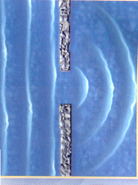
When the waves came hindered by obstacles such as a breakwater or island, the waves will be turned on around the end of the barrier and entered the protected area behind it. Diffraction occurs when there are differences in the sharp wave energy along wave crests. At first the conditions in the protected area barrier quiet enough (there are no waves), as a wave across the barrier. Waters far from the barrier will have more energy (initial wave energy) than the waters behind the barrier which had been quiet (no energy because there are no waves), the energy transfer process occurs at the crest length to the area of protected coastal buildings.
Transfer energy to the establishment of protected areas causing waves in the area, though not as big waves outside the protected areas. Crest lines in the back and have turned obstacles arc shape with its center at the end of the obstacle. Considered that the water depth is constant. If not, then it also occurs in addition to the diffraction wave refraction. Usually reduced wave height along the crest toward the protected area.

When the wave went through a structure there will be a transfer of wave energy in line with the peak of the wave inside the structure. Concentration of energy density will lead to periods of higher waves of the spectrum. With KD to determine the distance from the wave period and direction, one can evaluate the characteristics of the wave spectrum at a point in
areas protected by coastal structures in order to plan the wave damping structure.

Wave Breaking


Wave breaking can be categorized into the following three types.

1. Spilling
Spilling waves usually occur when a small slope towards the flat beach (small slope). Waves breaking at a considerable distance from the beach and the outbreak occurred gradually. Foam occurs at the peak of the wave during broken and left a thin layer of foam on a long distance.

2. Plunging
If the slope of the wave and the base increases, the wave will break and the peak wave will play with the mass of water at the peak of the wave will jump to the front. Broken wave energy was destroyed in the turbulence, a small portion is reflected to the sea coast, and not much new wave occurred in the more shallow water.

3. Surging
Surging occurs on the beach with a very large slope, as happened in the rocky shore. Region is very narrow wave broke, and most of the energy reflected back into the deep ocean. Surging type breaking wave is similar to the plunging, but before the top falls, the basic wave has broken.

Beach Behavior

Coast is a dynamic interaction between water, wind and soil materials. Water and wind move from one place to another, eroding the soil and then deposited so that the shoreline changes. The process of coastal change is a dynamic process, and if this continues it will interfere with the activities around the coast, because it will happen or erosion and accretion in the coastal area. According to Kakisina (2004) beach behavior can generally be categorized into 3 types, namely:

1. The beach is eroded (erossion coast).
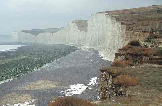
Coastal erosion of the shoreline setback to the ground, which can damage residential areas and urban infrastructure. Beach erosion can occur naturally due to wave attack or because of human activities in the form of mangrove deforestation, taking coral beach, port development, reclamation and others.

2. The beach is stable (stable coast).
The beach is basically the same stable with the eroded coast beaches where stable behavior is constant. This means that although the volume profile fluctuates, but overall volume is not changed with time.

3. Beach accretion (acresting coast).
Beach accretion mechanism is also similar to coastal erosion and a stable, only shoreline moves toward the sea. This means that fluctuations in the volume of the profile increases with time.

Artificial Causes of Coastal Erosion


Artificial causes of coastal erosion include:

a. Soil degradation
Soil degradation can occur due to ground water taking uncontrolled, or due to oil and other mineral materials.

b. Quarrying sand
One reason for coastal erosion is the excavation of sand and other minerals from coastal areas and beaches. Excavation will reduce the reserves of sand in the area that can be eroded coastline.

c. Coast parallel transport interruptions
This can happen because it perpendicular to the beach building. Perpendicular to the building can withstand transport rate of sediment transport from upstream, so the lack of sediment downstream, the result will occur in the upstream place accretion and erosion downstream.

d. Reduction of sediment supply to the beach
Supply blood circumstances beach sediment can occur due to human activities on land, such as the construction of dams and river regulation. Because of reduced sediment supply there will be transport beach material.

e. The centrality of wave energy on the beach
Making a building can lead to coastal wave energy concentration in the area, it can cause erosion.

f. The destruction of natural protection
In general, the beach has such a natural protective vegetation and a sand dune reserve. Destroying or the protective nature can result in coastal areas exposed to waves, so that these protected areas have no protection against the onslaught of the waves.

Natural Causes of Coastal Erosion

Natural causes of coastal erosion include:

a. Rising sea
Rise in sea level in the long term common in many places in the world. Sea level rise due to the relative decline in the face of the land (Land subsidence) or because of sea level rise is absolute. As a result of rising sea level, the shoreline may be backed slowly toward the mainland

b. Changes in sediment supply
Supply of sediment to coastal areas can be derived from the mainland (blastic sediment) or from the sea (biogenic sediment). Change in the sediment source of bias caused by the natural process of rock weathering on land or due to reduced river flow carrying sediment. Reduced sediment supply from the sea can be caused by a damaged reef areas or coral growth inhibition.

c. Storm Waves
Storm surge could cause beach erosion, this is caused by the storm occurred during the current perpendicular to the beach big enough to carry beach material. Generally the process of erosion caused by storm waves iniberlangsung in a short time and are termporer, because the eroded material will be left in the surf zone and will return to shore on a wave saait calm (swell). However, if the monitor is steep bathymetry and have trenches beach sediment carried in the unbiased back to the beach.

d. Overwash (runoff)
Overwash occurs when a high tide accompanied by high waves hit the coast passing over the tongue of sand (dune). As a result of the tongue Overwash be eroded beach sand and deposited on the inside tongue of sand.

e. Transport parallel to the beach
Selection (sorting) beach material can be changed according to the gradation of grain and circumstances of this wave resulting from wave activity. These changes may result in changes to the shoreline or beach erosion and accretion.

f. Transport by wind
Coastal erosion can be caused by sediments by wind terangkutnya land. Wind berberan in distributing sand beach in the direction parallel to the beach, where sand supply is smaller than the transport capacity then the erosion of coastal winds can occur.